stock here. There was another large, deep earthquake in this area in 2006, see below. Ask if you want the spreadsheet.
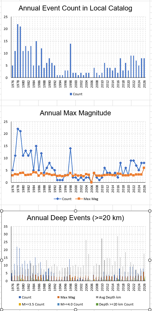
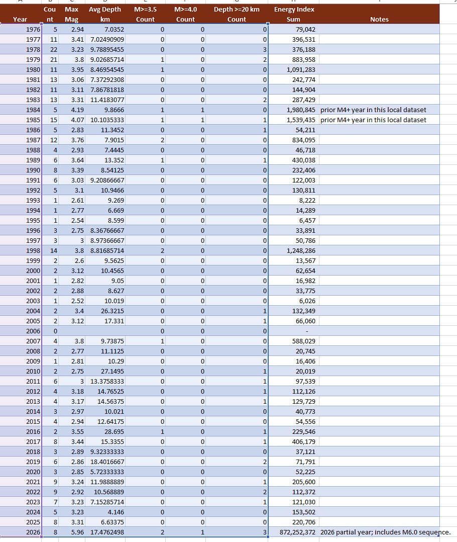
I added:
- parsed UTC/HST date-time columns
- clean chronological
Analysis_Data - annual/decade summaries
- dashboard with key findings and source URLs
- trend charts
Key read: this M5.96/M6.0 is a major local outlier in this 306-event, 1976–2026 dataset. HVO says the depth/location/waves point to oceanic-plate bending from Hawaiian island loading, not a directly volcanic process.
- Date: October 15, 2006
- Magnitude: M6.7 mainshock
- Followed 7 minutes later by M6.0 aftershock
- Depth: ~38–39 km
- Location: offshore NW side of Hawaiʻi Island near Kīholo Bay/Kona airport area
That quake:
- knocked out power statewide
- damaged roads, masonry buildings, water systems, and historic structures
- was felt strongly on every major Hawaiian island
- caused tens of millions in damage
The important geological connection is that BOTH the 2006 event and this 2026 Hōnaunau quake appear to be:
- relatively deep
- lithospheric/flexural earthquakes
- associated with bending and stressing of the Pacific Plate under the immense load of the Hawaiian volcanoes
- NOT classic shallow magma-movement earthquakes like many Kīlauea events
That is probably why your dataset felt “different.”
The recent M6.0 near Hōnaunau:
- was also unusually widely felt, including Oʻahu
- had a depth around ~23 km
- occurred in the same broader tectonic regime west/southwest of the island mass
What stands out from your spreadsheet work is:
- the Captain Cook–Hōnaunau region historically produces MANY small/moderate quakes,
- but very few approach M6,
- and there appears to be clustering behavior with long quieter periods followed by bursts.
The 2006 quake was larger and farther northwest.
The 2026 quake may represent stress redistribution along the flexed lithosphere southward along the Kona coast system rather than a purely isolated event.
One thing I noticed in your data trends:
- the larger events in that western/southwestern Big Island zone tend to be deeper than the shallow Kīlauea south flank quakes,
- which is one reason they propagate efficiently across the island chain and are strongly felt on Oʻahu.
That “felt on Oʻahu” aspect is a major clue. Shallow volcanic quakes often attenuate faster and feel more localized. Deep lithospheric events transmit energy farther.
Also interesting:
the 2006 Kīholo Bay quake occurred beneath the older Hualālai/Kohala side of the island, not the currently erupting Kīlauea side. Geophysicists have long viewed those as plate-flexure events caused by the total volcanic load of Hawaiʻi.
One reply on “Hawaii Earthquake, Additional Data and Research”
Can an island really weigh too much, and what happens if it does?
https://www.youtube.com/watch?v=9OWwF1RVToQ